Showing posts with label Netherlands - 9. Show all posts

23/06/2014

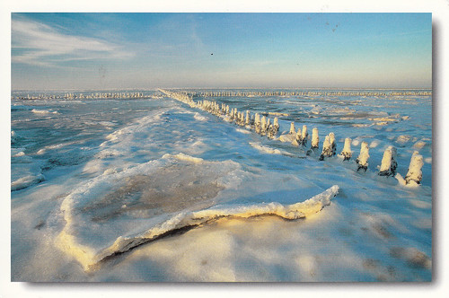
Netherlands, Germany - The Wadden Sea

As i'm sitting in a terrible boring Lecture and i have my MAC with me i'm able to post one more Site from my collection. 

The Wadden Sea comprises the Dutch Wadden Sea Conservation Area and the German Wadden Sea National Parks of Lower Saxony and Schleswig-Holstein. It is a large temperate, relatively flat coastal wetland environment, formed by the intricate interactions between physical and biological factors that have given rise to a multitude of transitional habitats with tidal channels, sandy shoals, sea-grass meadows, mussel beds, sandbars, mudflats, salt marshes, estuaries, beaches and dunes. The inscribed site represents over 66% of the whole Wadden Sea and is home to numerous plant and animal species, including marine mammals such as the harbour seal, grey seal and harbour porpoise. It is also a breeding and wintering area for up to 12 millions birds per annum and it supports more than 10 percent of 29 species. The site is one of the last remaining natural, large-scale, intertidal ecosystems where natural processes continue to function largely undisturbed.


The Wadden Sea


unesco_0061


The Wadden Sea


The Wadden Sea


28/07/2013

Netherlands - Rietveld Schröderhuis (Rietveld Schröder House)

The Rietveld Schröder House in Utrecht was commissioned by Ms Truus Schröder-Schräder, designed by the architect Gerrit Thomas Rietveld, and built in 1924. This small family house, with its interior, the flexible spatial arrangement, and the visual and formal qualities, was a manifesto of the ideals of the De Stijl group of artists and architects in the Netherlands in the 1920s, and has since been considered one of the icons of the Modern Movement in architecture.
Date of Inscription: 2000


Postcard 1: aprilRR - 56 - stephany


Rietveld Schröderhuis (Rietveld Schröder House)


Rietveld Schröder House
RAS from Christel


14/05/2013

Netherlands - Seventeenth-century canal ring area of Amsterdam inside the Singelgracht

The historic urban ensemble of the canal district of Amsterdam was a project for a new ‘port city’ built at the end of the 16th and beginning of the 17th centuries. It comprises a network of canals to the west and south of the historic old town and the medieval port that encircled the old town and was accompanied by the repositioning inland of the city’s fortified boundaries, the Singelgracht. This was a long-term programme that involved extending the city by draining the swampland, using a system of canals in concentric arcs and filling in the intermediate spaces. These spaces allowed the development of a homogeneous urban ensemble including gabled houses and numerous monuments. This urban extension was the largest and most homogeneous of its time. It was a model of large-scale town planning, and served as a reference throughout the world until the 19th century. 

Date of Inscription: 2000 

Postcard 1: Capital City offer tag from diashaliz 


Postcard 2: a Meeting card from giorgis


Seventeenth-century canal ring area of Amsterdam inside the Singelgracht
WriteBackRR - 5 - pebbles84

Seventeenth-century canal ring area of Amsterdam inside the Singelgracht
NL-1191590

Seventeenth-century canal ring area of Amsterdam inside the Singelgracht
NL-1258331
Seventeenth-century canal ring area of Amsterdam inside the Singelgracht
NL-2067477

15/11/2011

Netherlands - Mill Network at Kinderdijk-Elshout

The outstanding contribution made by the people of the Netherlands to the technology of handling water is admirably demonstrated by the installations in the Kinderdijk-Elshout area. Construction of hydraulic works for the drainage of land for agriculture and settlement began in the Middle Ages and have continued uninterruptedly to the present day. The site illustrates all the typical features associated with this technology – dykes, reservoirs, pumping stations, administrative buildings and a series of beautifully preserved windmills.

Date of Inscription: 1997

Postcard 1: januaryRR - 10 - Trickysticky


Postcard 2: juneRR - 2007 - marcha

Postcard 3: novemberRR - 02 - roos


Postcard 4: Official Postcard NL-718777


14/11/2011

Netherlands - Ir.D.F. Woudagemaal (D.F. Wouda Steam Pumping Station)

The Wouda Pumping Station at Lemmer in the province of Friesland opened in 1920. It is the largest steam-pumping station ever built and is still in operation. It represents the high point of the contribution made by Netherlands engineers and architects in protecting their people and land against the natural forces of water.

Date of Inscription: 1998

Postcard 1: MarchRR - 30 - Annerie


13/11/2011

Netherlands - Historic Area of Willemstad, Inner City and Harbour, Curaçao

The people of the Netherlands established a trading settlement at a fine natural harbour on the Caribbean island of Curaçao in 1634. The town developed continuously over the following centuries. The modern town consists of several distinct historic districts whose architecture reflects not only European urban-planning concepts but also styles from the Netherlands and from the Spanish and Portuguese colonial towns with which Willemstad engaged in trade.

Date of Inscription: 1997


12/11/2011

Netherlands - Droogmakerij de Beemster (Beemster Polder)

The Beemster Polder, dating from the early 17th century, is is an exceptional example of reclaimed land in the Netherlands. It has preserved intact its well-ordered landscape of fields, roads, canals, dykes and settlements, laid out in accordance with classical and Renaissance planning principles.

Date of Inscription: 1999

Postcard 1: aprilRR - 18 - muldj01


11/11/2011

Netherlands - Defence Line of Amsterdam

Extending 135 km around the city of Amsterdam, this defence line (built between 1883 and 1920) is the only example of a fortification based on the principle of controlling the waters. Since the 16th century, the people of the Netherlands have used their expert knowledge of hydraulic engineering for defence purposes. The centre of the country was protected by a network of 45 armed forts, acting in concert with temporary flooding from polders and an intricate system of canals and locks.

Date of Inscription: 1996

Postcard 1: JanuaryRR - 61 - muldj01